Kumeyaay Sense of the Land and Landscape
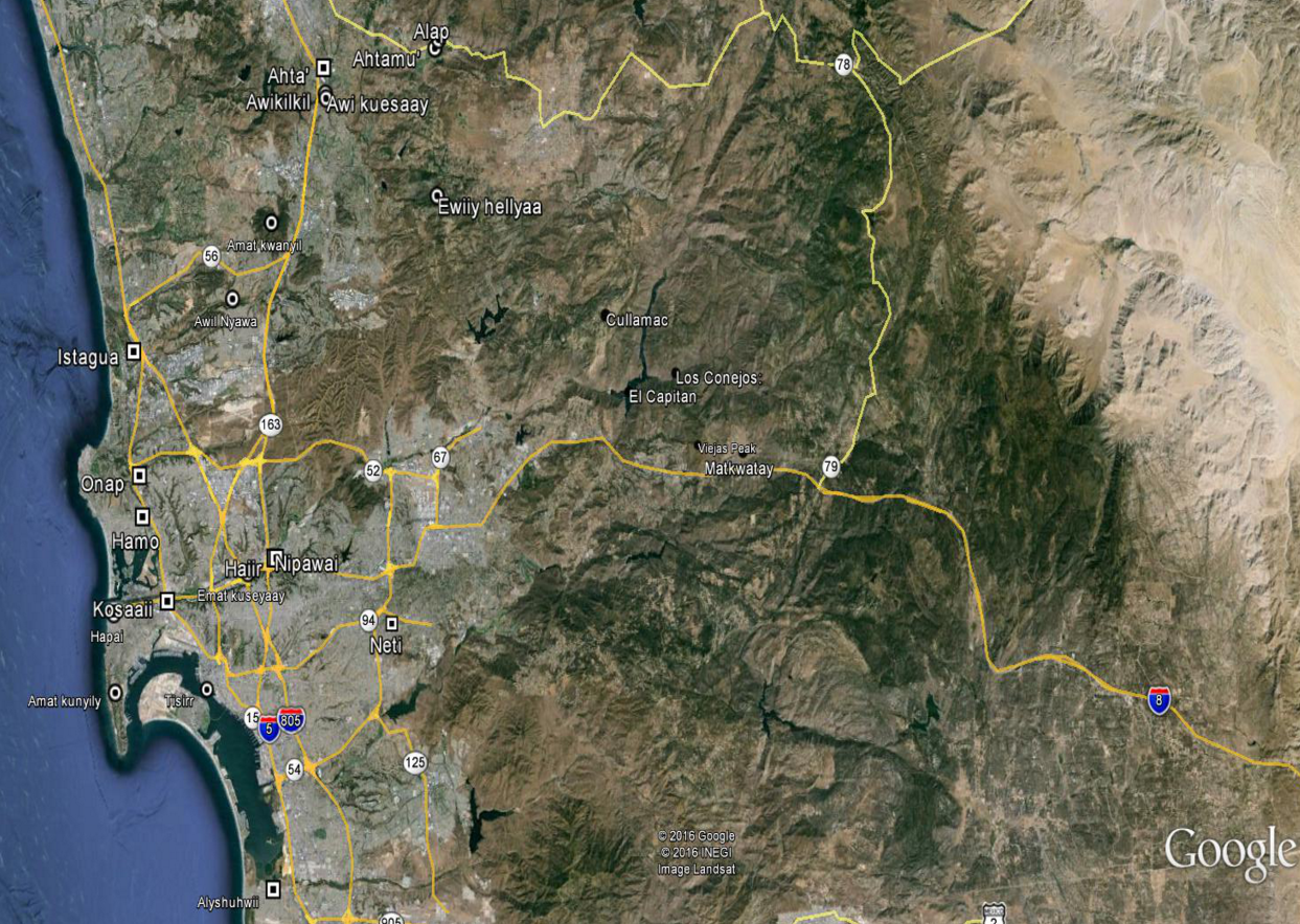
Today many of the bands of Kumeyaay live on or are enrolled on federal reservations. But this was not always so—the reservations were only established in the late 1800s and Kumeyaay (Ipai and Tipai) occupied San Diego and Imperial Counties for thousands of years. We traditionally lived in large semi-permanent villages with one pattern supporting villages on the coast with a second village in the interior mountains. A second pattern included mountain villages and desert settlements. The villages were set up along long established lineal lines with clans or sibs forming the political and social basis for which families inhabited each village and which families claimed first rights to resources in their area (acorns, mesquite, fish, and wild game). A good example of this was the settlements at Capitan Grande (Cullamac) and Los Conejos. Present-day Viejas and Barona were set up after the forced removal of the people of Capitan Grande and Los Conejos in the 1930s.
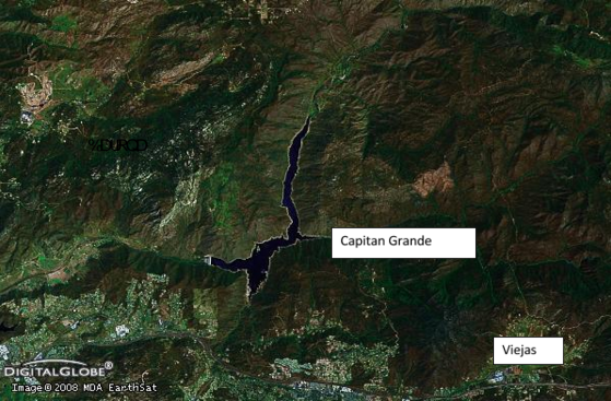
CAPITAN GRANDE: THE HOMELAND FOR THE VIEJAS AND BARONA BANDS
Boundaries as perceived in the European sense did not exist except in the way that the Creator had divided up the lands and resources amongst the Tribes and clans. While tribal and village “territories” were recognized, these areas in were constant flux and were open to be shared with other groups upon requesting permission to do so.
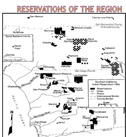
THE RESERVATIONS OF SAN DIEGO COUNTY
The traditional method by which most anthropologists have categorized the Kumeyaay does not adequately portray the complex and full understanding that the native people had of the land and of its resources. Certainly the Kumeyaay were not simple “hunter and gatherers;” instead they are best perceived as collectors, hunters, fishermen, and land managers with a vast knowledge of the plants, animals, and natural resources from the Pacific Ocean to the Colorado River and well into Baja California and the Sea of Cortez. Within this large and varied sphere of influence, the Kumeyaay developed and used an expansive network of trails that generally flowed from west to east following the drainages and landforms. These ancient trails linked villages, springs, natural resources, and sacred places such as Mount Woodson on the west, Viejas Mountain, Signal Mountain, Eagle Mountain, Table Mountain, Granite Mountain, and places far flung from the desert floor.
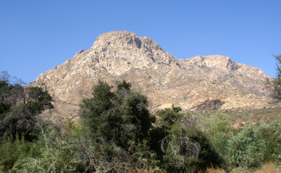
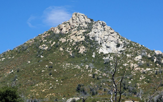
EWIIY HELLYAA (MOUNT WOODSON) KNOWN AS MOON MOUNTAIN AND AS ONE OF THE IMPORTANT KUMEYAAY SENTINELS
PLACES OF POWER AND MEANING
While all places on the land are of importance to the Kumeyaay some are imbued with special powers. The power can be derived from a mythical event that occurred there, by the use of a lace by spiritual leaders, or by other means. Particularly important are prominent peaks, noticeable rock formations, springs, and waterfalls. The following examples are by no means exhaustive but provide a comprehensive overview to those places that most often identified in the literature and through interviews.
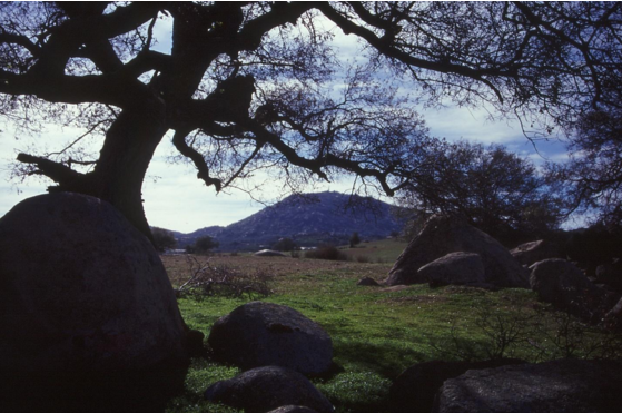
Viejas Mountain/Peak: This prominent peak just west of Viejas Valley is a solstice observatory used to site sunrise on the morning of the winter solstice (refer to the Astronomy section for more details). Some elders also tell of old women hiding there for protection from Spanish soldiers who traveled through the area. Associated with the mountain is an ancient dance ground known ass kwut-ahlyeah meaning dance song or where the dance songs are heard/sung (Harrington 1925).
Eagle Mountain: An imposing mountain in the eastern desert known as wii’ishpaa is believed to be occupied by powerful spirits. Torrie Burch related that at the top of the mountain there are rocks that hold evil power and spirits that can kill a person (Burch 2015:Interviews). In the Spanish and American periods wii’ishpaa came to be known as Signal Mountain.
Jacumba Hot Springs: In addition to being a place where some Kumeyaay could cleanse themselves in the hot muds and waters, a place at the base of a hill there is where two mythical brothers, Tuchaipa and Yokomatis, emerged from the ground (DuBois 1907:229). One of the Kumeyaay songs is supposedly derived from the Kachawharr travel song about two brothers who travel long distances alone—going on past many villages and people. This song is said to have originated at Jacumba and was then told to the Manzanita people from where it spread to other settlements and singers.
Table Mountain: There are two Table Mountains in the southern Kumeyaay territory. One is in the United States and one is just south of the border. The American peak is called mat llapillap in general meaning flat topped. But when alluding to its spiritual power it is known as mat-kusiyaay or witches’ mountain/sacred mountain.
Pilot Knob: Pilot Knob is of course a highly prominent peak rising from the desert floor along the border like a sentinel. Known as mut kwinpuur or mat winpuur, it is known as a spiritual place where mystical and magical events occur.
Mount Woodson: Known as Ewiiy Hellyaa is located in western Ramona and is place of power associated with a mythical rabbit and with the moon. According to some stories Ewiiy hellyaa is where the moon sleeps. J. P. Harrington recorded a story of a Kumeyaay spirit giant (Toyapai) who stepped on the southern slope of the mountain on his way to the coast. Toyapai’s foot imprinted into the bedrock and the hillslope is steeply indented. These features can still be seen today.
Tecate Peak: Known as Kuuchama, is on the International Border near the community of Tecate and is considered to be one of the most sacred places in San Diego County. It is said that Kuuchama is a place inhabited by very powerful spirits and a place where beginning kuesaay went for their final training and indoctrination. It is also believed that those without adequate training and understanding should not venture to its more sacred spots.
Cowles Mountain: High above Mission Trails Regional Park Cowles Mountain is the site of a now-destroyed solstice observatory. The heavily used trail and mountain is still considered important to many Kumeyaay.
Chaup’s Home: Even though the fireball spirit Chaup has a permanent home in the San Bernardino Mountains, a collection of large rocks and overhangs in San Pasqual Valley is where this powerful fireball occasionally lives. According to Kumeyaay elder Isidro Nejo in 1925 this site was to be avoided and even though it afforded shelter and warmth to travelers, no Kumeyaay would spend a night there.
Awi-Kuesaay: Known as the “witched rock” or “spirit rock,” this ringing rock east of Lake Hodges is associated with the ancient village of San Pasqual and is noted in early stories as a place where a kuesaay could ring the rock and call the east wind (Carrico 2014; Roberts 1917:117). This rock formation played a major role in defeating Yuman (Quechan) intruders into San Pasqual Valley sometime in the 1830-1860 era (Carrico 2014; JPH 1925).
Awi-Kwapay: This rock is near the Vallecitos Adobe in the eastern desert. According to some elders an important Kumeyaay leader and singer of the old songs including the Fire Dance once sat on this rock. It is said that if one goes to the rock and is good of heart and spirit the old songs and stories can be faintly heard (Wilson 1958:5-6; Elliott 2014: Interview)
Stonewall Peak: According to a story related by J. P. Harrington a fearsome Kumeyaay monster lived in an overhang on the west side of this prominent peak in the Cuyamacas. Additionally it has always been known as place of power in part because of the presence of teaxon/teahon a type of soapstone.
Mem-sha-wee: This is a spring with magical powers. Located at Mesa Grande, people who drink from it will always want to return there (Roberts 1917:178-179).
A Look Into the Villages and Place Names in the Viejas Region
Jacunmat: El Corral
Traveling east up river from the mission in the valley that was then called San Luis and later El Cajon towards Viejas, there existed a large village of Tipai. Because the mission and presidio kept livestock in the valley and built corrals, the village became known as El Corral. Apparently soldiers on guard duty away from the presidio and mission raped and brutalized several people from this village. Family/clan names at Jacunmat included Meteguir (Duro), Guassalpoc (Guassac), and Cullin. In 1779 the kwaipay of the village was 26-year old Raphael Maria Cullin. Interestingly, eight years later in 1787 his father, Francisco listed as 80 years of age, was noted as the kwaipay of the village upon his death, although this may have been an honorary attribution.
Los Conejos
Los Conejos, the rabbits, is a village just beyond the eastern boundary of the Capitan Grande Indian Reservation. This village is not well-documented in the Spanish or early historical literature because of its remoteness. Its traditional name is Hellyaaw nyewa—rabbit’s home.
Los Conejos was abandoned when its occupants were forced to move in 1935 in advance of the filling of the Capitan Grande Reservoir. The majority of the Los Conejos people moved to Viejas Reservation after the City of San Diego purchased and established it through the federal government for their relocation.
Matkwatay
This is the traditional name for what is now Valle de Viejas and the Viejas Reservation and may mean large land or big land.
Cullamac
Even if there was not an Indian Reservation known today, and since 1875, as Capitan Grande and even if there were no collective memory of the people of Barona and Viejas of their homeland once being at Capitan Grande, a known place on the land, it would be possible to locate the site of Capitan Grande, and therefore Cullamac. This is because both Capitan Grande and Cullamac have been recorded place names for more than 130 years.
Place names in southern California reflect a unique blending and metamorphosing of Indian, Spanish, Mexican, and American spellings and pronunciations. Every culture has a seemingly innate need to name place on the land. For the Kumeyaay the name often reflected a natural feature or important event that occurred there. [give examples here-Jamul, Jamacha, Guatay] In contrast, the Spaniards, especially during their explorations when accompanied by a priest, named places for saints and plants. Americans tended to be less profound, using person’s names, descriptions of landform, and whimsy. Many places in San Diego County have had names that reflected all three cultures. In the case of Capitan Grande and Los Conejos (both Spanish words for the great or grand captain/leader and for the rabbits, respectively), Kumeyaay people had names for these settlements and their environs long before Spanish settlement in 1769.
To derive the Kumeyaay names for the area that is now Capitan Grande and El Capitan, it is necessary to find that point in time that Capitan Grande was referred to as a name on the land and to see if an earlier, pre-European, or Kumeyaay name is provided. This is important because place names and names of settlements allow the researcher to place the area or village associated with the name(s) in a context.
A review of Catholic baptismal records for the period 1769-1822 reveals that Indians from Capitan Grande alias Cullamac were baptized and therefore provide family and clan names and pinpoint the presence of a large village as early as 1779. Over a period from the first baptism in 1779 to the last baptism in 1815, more than 80 villagers from Cullamac were baptized (Libros de baptismo 1769-1822). Most often the notation in the baptismal record simply lists Cullamac as the residence of the villager. Importantly, for some baptismals [cite these] the priest noted the place of residence as Cullamac, stating “also known as, alias, Capitan Grande.”
This would indicate that for the Franciscan priest conducting the baptismals, the Spanish name Capitan Grande demarcated a known village site or settlement and that the Indians (Kumeyaay) knew the place as Cullamac. In the early years of Spanish conversion and colonialism it was common for the officiating priest to give both a native name and the Spanish name for settlements and locals. By the late Spanish era, circa 1800 and the Mexican period circa 1821, the Indian names were less commonly used.
Working back from the 1779 baptismal at Capitan Grande (Cullamac) it is possible to establish how the Spanish nomenclature of Capitan Grande became attached to the Kumeyaay settlement of Cullamac. Following the Kumeyaay insurrection of November 1775, which resulted in the destruction of Mission San Diego de Alcala, an intensive investigation was conducted by Spanish officials (Carrico 2000). After weeks of interrogation of captured Kumeyaay, Lt. Ortega reported that one of the most important cabecillas (ringleaders) of the mission revolt was Francisco the captain (kwaaypaay) or leader of the mountain village of Cullamac (Ortega 1775). Francisco’s role in the uprising and his obvious status within his village led to him being known as el capitan grande.
Seven years later, in 1782 Pedro Fages, on one of his entradas across the mountains, noted that as he traversed southeast out of the mountains and into what is now the San Diego River canyon east of El Cajon, he passed near the village of the Capitan Grande. This may be the first time that Capitan Grande was applied to the settlement of Cullamac although earlier instances may exist. The appellation “Capitan Grande” saw continued use and came to gradually replace the Kumeyaay word Cullamac. In a newspaper article written by local historian John Davidson in April 1938, he noted the antiquity of the name Capitan Grande, and by inference, the Kumeyaay settlement there. Davidson wrote, “…its [El Capitan Grande] history goes back to mission times—before an American state was dreamed of here. The name itself is one of the earliest in our records. The Spanish form means of course the Canyon or Valley of the Great Captain.”
The meaning of the name Cullamac provides further clues as to its setting and location. Edward Davis, who lived with the Ipai at Mesa Grande and studied their culture and history for several decades, wrote that the Indian name for El Capitan Grande was E-quilsh-a Mahk (Davis 1945), which he translated as “behind the mountain.” As noted by Rensch (1956:32), and by this researcher, Davis consistently heard the sound “sh” after the sound “l” or “ll” and orthographically recorded Kumeyaay words as such. Thus a more accurate rendition of the word would, in English, be E-quil-a-mak, a close construct to the Spanish Cullamac. Ted Couro and Margaret Langdon (1975) provided an orthographic spelling of Kwellyemak for Capitan Grande. Other, less accurate definitions of the word have been provided including Quil-ach-nusk meaning “long valley’ (Davidson 1938).
CULLAMAC (THE SHOULDER BLADE) EL CAPITAN
“Cull-a” or “Quila/Quilsh-a” means mountain in Tipai and “Mak” or “Mac” means behind. Cullamac, or Davis’ E-quilsh-a-Mahk can be translated as behind the mountain. Rensch (1956: 32) quotes early American pioneer and astute observer of local places, Judge Benjamin Hayes on the setting for Capitan Grande. In 1867 Hayes visited Capitan Grande and wrote that, “Immediately behind the peak is the Indian village called Capitan Grande.” The peak is El Cajon Mountain, sometimes known as El Capitan Peak or Capitan Grande Peak. Without using the Kumeyaay word Cullamac, Hayes conveyed the same concept—behind the mountain.
Cullamac/Capitan Grande: Roots of the Viejas People
Today’s Kumeyaay people who live at Barona and Viejas Indian Reservations can trace their ancestry back to Cullamac as well as to other villages and settlements, including the Mission San Diego. Analysis of the Spanish baptismal records for the period 1779-1815 reveals several family names and clans that once occupied the Cullamac/Capitan Grande area. It is beyond the scope of the current study to attempt to translate all of the baptismal records for Cullamac and to decipher the Spanish orthographic presentation of Kumeyaay family names. However, a cross section of the available data is of interest and value.
Several of the Kumeyaay women noted in the baptismal record for Cullamac are orthographically represented by the prefix “Sin” or “Siny,” the Kumeyaay word for woman. Examples include Sinfora (Beatrice), Sincan (Felicitas), Sinchafin, Sinjowich, Sinparo, and Sinesyulp. The name Mechecat was given for a sixty year old woman who was baptized as Feliciana. Mechecat is also a family name that later became Duro (Shipek). Almost 100 years later, Judge Benjamin Hayes reported that the leader of the Los Conejos village near Capitan Grande was Jose Duro, son of Me-cha-te, possibly indicating some lineal continuity extending back to the Mechecat (Me-cha-te) family or clan of the 1700s.
Precontact Settlement at Cullamac/Capitan Grande
Based on the information provided above it is clear that a Kumeyaay settlement known to the natives as Cullamac and to the Spaniards as early as 1782 as Capitan Grande existed in the valley behind El Cajon Peak as the San Diego River bends to the north. A review of the archaeological literature for the area indicates that the settlement of Cullamac and its outlying camps extend back into the prehistoric era. In San Diego County prehistory is traditionally perceived to have ended in 1769 when the Spaniards arrived and began the process of converting the Kumeyaay and leaving written records about them. The Kumeyaay people who lived here prior to Spanish colonization have roots extending back thousands of years. There is conjecture about when the Kumeyaay as an distinct ethnic and cultural stock began in San Diego. Kumeyaay oral tradition and written versions of their creation stories would seem to indicate that they migrated into the area from the deserts along the Colorado River.
The earliest dates for human occupation in San Diego County hover around 9,500 years ago although there is no direct evidence to tie the sparse information for this time period to the Kumeyaay. A large population of largely coastal dwellers has been documented for the period 8,000 to 3,000 years ago and archaeological excavations have produce human burials and a wealth of information regarding these people. Known as the people of the La Jolla Complex, it has been suggested (Bull) that these people were Hokan-speaking people with some relation to the Kumeyaay. Physical anthropologists have not found forensic correlations between the people of the La Jolla Complex and the Kumeyaay population suggesting that they are ethnically or racially, a different people.
While there is uncertainty about extending the Kumeyaay occupation of San Diego back beyond 3,000 years, there is substantial evidence that by 2,000 years ago, and probably 3,000 years ago, the direct ancestors of the current Kumeyaay people occupied the region. The presence of small arrow points, pottery, and cremation of the dead are characteristics of the Late Prehistoric Period and of the Kumeyaay culture. Other traits include the use of black obsidian from the Imperial Valley, manufacture of Desert-side notched arrow points, construction of stone terraces, and bedrock milling focusing on mortars for the processing of acorns.
Guatay
Guatay also spelled as Wahti and Guatai, is one of the Kumeyaay placenames that has endured on the landscape and on maps.
Cushi-Pi
Stonewall Peak, known to our people also as Cush-Pi meaning “Sharp Peak” is one of the prominent landmarks in the Cuyamaca Mountains. Steatite (soapstone) from Cushi-pi was quarried and used for a variety of purposes by the Kumeyaay. This shared resource became arrow shaft straighteners, pipes, effigies, sucking tubes, and in powder form carried magical power.
Hutstah-tah-miltah
Commonly known as South Peak within the Cuyamacas, the Kumeyaay meaning is “Hanging Head” or Head That Hangs.”
CUSHI-PI (STONEWALL PEAK) IN THE CUYAMACA MOUNTAINS IS BOTH AN IMPORTANT LANDMARK AND A SOURCE OF HIGHLY PRIZED SOAPSTONE

Kumeyaay Place Names Mark the Land and Tell Our Stories
Selected Kumeyaay Villages and Settlements in San Diego County